Gold deposits in Russia on Igor Garshin’s website
Home
| Write |
Home > Natural Sciences > Earth Sciences > Geosphere Sciences > Geology of Gold > Gold Mines of the World > Gold in Russia
Alphabetical list of pages: | | | | | E (Yo) | | | | | | | | | | | | | | | | | | | | | | | | 0-9 | AZ (English)
The page contains information about metallogenesis and Russian gold mining (with a list of gold mines and mines in Russia).
Page sections:
| Other interesting pages:
|
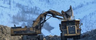
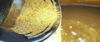
Gold mining industry in Russia
In Russia, gold reserves are recorded in 372 primary deposits, as well as in more than 5,000 placer deposits. In terms of the amount of gold reserves, Russia is second only to South Africa, possessing 12.5 thousand tons of the precious metal, or more than 11% of the world's reserves; Of these, industrial reserves (categories A+B+C1) account for about two-thirds, or approximately 8 thousand tons of metal.
In terms of gold production in 2011, Russia, ahead of South Africa, again took fourth place in the world after China, Australia and the United States.
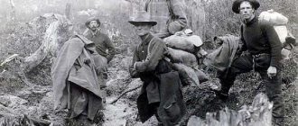
How and where gold deposits can be developed
In many countries of the world (Australia, Finland, some US states), the government solved the problem of private mining simply - it resolved it. All you have to do is buy a license and you’re welcome to the stream with your tray. Citizens are allowed to use what they have obtained at their own discretion.
It's different in Russia. It is almost impossible to become legalized as a gold miner, Art. 191 of the Criminal Code of the Russian Federation is in effect, and the found metal must be handed over to the state. The bill on civil liberties and the issuance of licenses has been considered in the State Duma since 2009, but has not yet been adopted.
A single miner should focus on the map of alluvial deposits, of which there are many in the Urals and Transbaikalia. There are abandoned mines, the residual deposits of which are of no interest to industrial developers. You can find gold in river basins:
- Sanarka;
- Lena;
- Bodaibo;
- Big Chanchik;
- Bom;
- Talga et al.
Also see below how gold is mined by a prospector:
Formation of gold deposits in Russia
Deposits of gold ores of different genetic types are known on the territory of Russia. Skarn
deposits are known in Siberia (
Olkhovskoye
).
Ore
bodies are represented by lenses and veins, complicated by apophyses.
The most common are hydrothermal
deposits, among which various gold-quartz formations stand out.
The gold-quartz-sulfide
formation includes
the Berezovskoye
deposit in the Urals and
the Darasunskoye
deposit in Transbaikalia.
Of practical interest are volcanogenic hydrothermal deposits in Archean
ophiolitic rocks within platforms and in young late geosynclinal andesite-liparite complexes (region
of the Pacific ore belt
).
These deposits are characterized by a complex composition of ores and an uneven bonanza concentration of gold, often combined with silver. Deposits of the gold-quartz-chalcedony-sulfide
formation (
Baleyskoye
,
Taseevskoye
in Transbaikalia) are represented by stockworks, linear vein zones and individual veins, accompanied by halos of disseminated mineralization.
Within their boundaries, industrial gold ores form ore pillars. The Karamken
deposit (
Okhotsk-Chukotka volcanic belt
) in northeastern Russia belongs to
the gold-silver-quartz-adularia
formation and is represented by veins and their bundles that fill faults and cracks.
The predominant part of reserves (more than 50%) of indigenous gold in Russia is concentrated in deposits of carbonaceous-terrigenous complexes. Gold deposits in the black shale formation have enormous reserves of hard-to-recover gold. These deposits are represented by objects of various sizes - from small to unique. These include the following deposits: Mayskoye, Olimpnadninskoye, Nezhdaninskoye, Sukhoi Log
. In Siberia, metamorphic black carbon-containing shales of Precambrian age are widely developed, in which dispersed primary gold content was regrouped under the influence of metamorphosing agents to form industrial deposits of gold ores.
In the Magadan region, Yakutia, eastern Siberia, and Transbaikalia, placer deposits have been identified and explored, among which alluvial placers
.
As for the metallogenesis of silver ores often associated with gold, all their commercial deposits are post-magmatic. Most of the silver deposits belong to volcanic-hydrothermal formations. To silver-gold
formations include
the Khakanja
(
Kakandzhinskoye
) deposit in
the Okhotsk-Chukotka
volcanic belt, and
the silver-lead
formation includes
the Mangazeya
group of silver-polymetallic deposits in the Yakutsk ACCP.
Mining of uranium ore in Russia. "Big Three"
According to the World Nuclear Association, Russia ranks 7th in uranium production in the world. Thus, in 2021, our enterprises received 2911 tons of strategically important metal used in various industries. And it just so happens that the largest uranium enterprises are concentrated in just three regions of Russia.
Where is uranium mined?
The richest active deposits of uranium ores are located in the Trans-Baikal Territory, Buryatia and the Kurgan Region. All uranium production enterprises are controlled by Rosatom's mining division, Atomredmetzoloto. Under his control are the real elders of the industry - PIMCU named after E.P. Slavsky, Khiagda and Dalur.
Transbaikal uranium
Transbaikal region, 1968. Here begins the story of the emergence of the largest domestic uranium mining enterprise - the Priargunsky Industrial Mining and Chemical Association named after E. P. Slavsky.
Huge reserves of radioactive raw materials located in the southeastern part of the Chita region were discovered by geologists in 1963. The Streltsovskoye ore field is located here, which united 19 uranium and molybdenum-uranium deposits in its depths. In 1968, the first sites began to be developed in the harsh Siberian subsoil, and at the same time the city of Krasnokamensk was founded near the new uranium center.

Now PIMCU is developing mine No. 1, No. 8 and Glubinny, although previously there were many more assets in operation. For example, mines No. 2 and No. 4 with total reserves of 18.5 thousand tons of uranium are in a state of conservation. Mine No. 2 was “frozen” in 2014 due to “economic inefficiency” caused by low uranium prices. And mine No. 4 was closed for the completion of reserves using the traditional mining method.
One way or another, PIMCU transferred all its forces to the revival of another closed mine - No. 6. Previously, it was one of the largest centers of Russian uranium mining. The deposits of the Argunskoye and Zherlovskoye deposits were mined here, the total reserves of which reach 40.9 thousand tons.
Mine No. 6 was mothballed during perestroika times. For many years, the ARMZ subsidiary tried unsuccessfully to resume the project. In 2018, the company announced its “entry into a new era of development.”
The industrialists decided to complete the mine and, together with it, create a new production infrastructure that would allow the annual production of up to 2.5 thousand tons of uranium oxide. The project is still being actively implemented today - according to the latest data, above-mine complexes are now being built at the mine.

In general, the mineral resource base of PIMCU is estimated at 97.8 thousand tons of uranium, which will be sufficient until the end of 2030. The company's operating mines provide at least 56% of the total Russian uranium production.
At the end of 2021, the ARMZ division produced more than 0.9 million tons of ore, exceeding the plan by 7%. PIMCU uses the resulting raw materials to produce uranium oxide, which is then redirected for further enrichment to Rosatom nuclear fuel cycle enterprises.
In the same 2019, the output volume of finished products amounted to 1,600 tons, and sales revenue reached 11.9 million rubles, which is 24% more than in 2018. In the future, the uranium division expects to increase processing volumes to 1 million tons of ore per year.
In addition, PIMCU is gradually switching to developing deposits using a safer method. Thus, in April 2021, a project for the technical re-equipment of the uranium ore heap leaching site was launched at the Hydrometallurgical Plant of the Mining and Chemical Association.
At the same time, the company launched local production of ARGO battery technology. Already, 7 loading and hauling machines are operating in underground mines; in 2021, another 8 units of equipment will be put into operation.
Uranium deposits "Khiagdy"
ARMZ's subsidiary Khiagda controls Buryat assets located within the Khiagda ore field. The first deposits on the territory of the modern uranium cluster were discovered back in the 80s. A series of large-scale geological exploration works made it possible to identify almost 45 thousand tons of uranium.
The industrial development of Buryat wealth began at the turn of the 2000s. Khiagda was discovered in 1997, and within a couple of years miners tried extracting uranium using the underground leaching method. The Khiagdinskoye field in the Bauntovsky district was chosen for pilot testing. To this day, it is considered a flagship uranium mining center, as it has 10.8 thousand tons of uranium reserves.

The second strategically important mining asset of ARMZ has recently become the Istochnoe deposit, in the depths of which lies more than 2 thousand tons of uranium. Khiagda began its development in 2021, and the first batch of raw materials was received only in 2019.
By the way: in 2021, Russian scientists created the first 3D model of a uranium deposit on the basis of Istochnoye. With its help, operators remotely “move” in the workings of an underground mine.
Today ARMZ regards Khiagda as the most promising division. In 2021, the enterprise produced 1 thousand tons of ore, reaching the “starting” design capacity.
According to the development program, Khiagda’s activities are projected until 2055. Because in the future there is development of deposits of other deposits of the Khiagda ore field. Let's start with the fact that before the onset of 2021, the company completed a large-scale project for the construction of all key infrastructure facilities on the territory of the central production site.
Already in the second half of 2020, Khiagda entered the final stage of preparation for the start of development of the neighboring Vershinnoye deposit, whose reserves exceed 4.6 thousand tons of uranium. The next stage in increasing production assets is the start of industrial development of the Kolichikansky field, planned for 2021.
Then next in line is the development of the Dybrynskoye field, remote from the central industrial site. Especially for it, Khiagda will build an installation for the production of uranium from productive solutions by extraction onto a special resin. As planned by the miners, the saturated resin will be transported for further processing to the main production building without the need for pipelines.

As previously mentioned by Viktor Svyatetsky, Dybrynskoye will become the first uranium deposit in Russia to be completely converted to digital technologies that will connect the mining process from an individual well to the level of an entire enterprise.
In the longer term, Khiagda plans to implement projects for the development of the still untouched Namaruskoye, Koretkondinskoye and Tetrakhskoye fields.
“The progressive development of Khiagda will make it possible to provide more than 30% of the production of strategic metal for the needs of the Rosatom State Corporation,” Viktor Svyatetsky said in August 2021.
Uranium of the Urals
"Dalur" embarked on the path of the "uranium king" of the Kurgan region in 2001. The main activities of the ARMZ division are focused on three fields: Dalmatovskoye, Khokhlovskoye and Dobrovolnoye. The total raw material base of the licensed areas is estimated at 18.5 thousand tons of uranium.
The search for Ural reserves began in the Zverinogolovsky region. Geologists discovered large deposits of the Dalmatovskoye deposit in 1979, and industrial mining began in the 80s - at that time, the site produced approximately 45 tons per year. However, in 1995, the Dalmatovo project was suspended due to lack of funding. Only with the founding of Dalur was the site reactivated, and now total production volumes reach 500 tons per year.
In November 2021, Dalur began geological exploration at the Dobrovolnoye uranium deposit. In terms of its scale, the site is comparable to Dalmatovsky: its contour contains just over 7 thousand tons of uranium. And in October last year, the exploration complex was successfully completed, confirming the industrial feasibility of the project.
Dalur plans to build a pilot in-situ leaching complex for the development of Dobrovolnoye, the productivity of which for productive solutions will reach 60 m3/h. With its help, the enterprise will produce ammonium diuranate pulp. The start of pilot work is scheduled for the current year 2021.
Dalur received a license for the third deposit in the Shumikha region - Khokhlovskoye - in 2004. Geological exploration was carried out in 2008-2009, and the company’s specialists also tested underground leaching technology.
But the implementation of the project dragged on for several years: thus, in 2019, the subsidiary of ARMZ again began preparing for the development of the site. In November last year, the company put into operation a number of infrastructure facilities: a chemical warehouse, a substation, and a water tower. The construction of a railway base for the transportation of chemicals on the Kurgan – Chelyabinsk railway is currently underway, which will significantly reduce delivery time.
Dalur will invest about 35 billion rubles in projects for the development of the Dobrovolnoye and Khokhlovskoye fields.
For the current year, Dalur has completely planned to relocate from the Dalmatovskoye field to the Khokhlovskoye field. As the general director of the enterprise, Nikolai Poponin, previously said, it is planned to extract the bulk of uranium at the new site.
Gold deposits in Russia
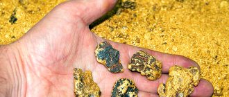
The most promising areas for searching for gold nuggets in Russia are located in its Asian part - these are the Urals, Bodaibo, Taximo, Amur, Magadan, Chukotka
.
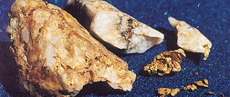
One of the large nuggets found in the Bodaibo region weighs 12.3 kg. In Chukotka (Bilibino), quite recently, a 16 kg nugget was found. In the Amur region on the Cuttlefish
, in the estuary part, 665 nuggets were found, the largest of which was 6.9 kg, and on the
B. Chanchik
in 2000 a nugget of 3.5 kg was found.
The list below of 46 (so far) gold mines and mines in Russia is divided by latitude-longitudinal zones. The belts are listed from west to east and are grouped by gold provinces (GMPs), within geographic zones or folded areas.
Gold mining provinces of the European part of the Russian Federation
In the European part of Russia there are 3 gold mining provinces: Karelo-Kola
,
Dnieper-Don
and
Caucasian
. Geographical and setallogenic information on the gold mines of these provinces is not yet available. Geographically, the gold mining geological unit No. 2 (“Buisky”) belongs to the Karelo-Kola ZRP.
Gold fields of the Caucasus province
The Kakadur ore zone is the only potential deposit of the precious metal in Ossetia.
The Sotk gold deposit is the largest in terms of pure gold reserves in Azerbaijan and Armenia.
Gold mining provinces of the Urals and Trans-Urals
The gold belts of Western Siberia listed below lie within the Siberian Trap
.
They belong to 4 gold mining provinces: Ural
,
Taimyr-Severo-Zemelskaya
,
Altai-Sayan
and
Baikal-Vitim
.
Gold-bearing belt from 50 to 60 N latitude. and from 60 to 65 east. (Ural)
- Berezovskoe
: - from 55 to 60 northern latitudes. and from 60 to 65 east. - Vorontsovskoe
: - from 55 to 60 north latitude. and from 60 to 65 east. - Kochkar
, or Kochkar gold deposit: - from 50 to 55 north latitude. and from 60 to 65 east. - Svetlinskoe
: - from 50 to 55 northern latitudes. and from 60 to 65 east.
Gold-bearing belt from 50 to 65 N latitude. and from 85 to 95 east.
- Kommunarovskoe
: - from 50 to 55 northern latitudes. and from 85 to 90 east. - Konstantinovskoe
: - from 50 to 55 northern latitudes. and from 90 to 95 east. - Olympics
(Olimpiada): - from 55 to 60 latitudes. and from 90 to 95 east. - Saralinskoe
(Saralinskoe): - from 50 to 55 northern latitudes. and from 85 to 90 east. - Soviet
(Sovetskoe): - from 60 to 65 northern latitudes. and from 90 to 95 east.
Gold-bearing belt from 45 to 55 N latitude. and from 100 to 105 east.
- Zun-Holba
: - from 50 to 55 north latitude. and from 100 to 105 east.
This zone also includes the Mongolian gold mines of Bumbat Gold Fields
(Bumbat Gold Fields) and Boro (Boroo).
Gold-bearing belt from 50 to 60 N latitude. and from 115 to 125 east. (Irkutsk region)
The northern part of this gold zone (from 55 to 60 N) belongs to the GZS zone No. 4 (60 N 120 E).
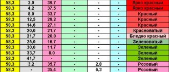
The springs closest to this point are marked in red. And mines that fall within the “statistical intersection” (i.e., in the range from 50 to 55 N and 115 to 120 E) are marked with an asterisk (see Conclusions).
- Verninskoe
(Verninskoe): - Irkutsk region (from 55 to 60 N and from 115 to 120 E) - Golets Vysochaishiy
: - Irkutsk region (from 55 to 60 N and from 115 to 120 E) - Darasun *
(Darasun): - Siberia region (from 50 to 55 N and from 115 to 120 E) - Kariisk *
(Kariisk): - region of Siberia (from 50 to 55 N and from 115 to 120 E) - Klyuchevskoe *
(Klyuchevskoe): - Siberia region (from 50 to 55 N and from 115 to 120 E) - Pokrovskoye
: - from 50 to 55 northern latitudes. and from 120 to 125 east. [east of others] - Sukhoi Log
: - Irkutsk region (from 55 to 60 N and from 115 to 120 E) - Taseevo *
(Taseevo): - region of Siberia (from 50 to 55 north latitudes and from 115 to 120 east longitudes) - Ukoninskoe *
(Ukoninskoe): - region of Siberia (from 50 to 55 N and from 115 to 120 E) - Chertovo Koryto
: - Irkutsk region (from 55 to 60 N and from 115 to 120 E) - Broad *
(Shirokaya): - Siberia region (from 50 to 55 N and from 115 to 120 E)
Sukhoi Log gold deposit
The deposit is located within the Bodaibinsky synclinorium, in the Kropotkinsky ore cluster, which occupies the central part of the synclinorium. The deposit belongs to the quartz-sulfide veinlet-disseminated type, combined with subordinate thin veins of quartz and gold-quartz composition.
The Kropotkinsky ore cluster is confined to the northern wing of the Maracan-Tunguska syncline, complicated by smaller folds. The unit is composed of a thick sequence of sedimentary rocks of the Patom series PR3, which is subdivided (from bottom to top) into the Ballaganakh, Kadalikan and Bodaibo subseries hosting the mineralization. Intrusive rocks in the node are represented by a large Konstantinovsky stock of granites PZ1 (Concudero-Mamakan complex) and a series of quartz porphyry dikes. These igneous rocks are absent within the deposit, and the deposit has no clearly defined connections with magmatism. Lower Proterozoic rocks are regionally altered in the chlorite-sericite subfacies of the greenschist metamorphic facies.
Gold mining provinces of Eastern Siberia
The gold belts of the Far East listed below in the north lie within the Verkhneyansk-Chukchi fold region
(
Verkhoyansk-Kolyma
,
Kolyma-Omolon
,
Novosibirsk-Chukotsk
,
Okhotsk-Chukotsk
,
Koryak-Kamchatka-Kuril
ZRP), in the south - not yet represented (
Mongol-Okhtskaya
,
Aldano-Stanovaya
,
Sikhote-Alinskaya
).
V.-Ch. With. O. - one of the most important ore provinces in the world. There are large deposits of gold (the basin of the rivers Boryolekh, Nera, Ayan-Yuryakh, etc.), tin (Deputatskoye, Chukotskoye), polymetallic ores and ores of rare earth elements (Imtanja, Tokichanskoye, Bulunginskoye, etc.), mercury, as well as stone coal (Zyryansky basin).
Gold-bearing belt from 50 to 60 N latitude. and from 125 to 140 east.
- Kuranakh
: - from 55 to 60 N latitude. and from 125 to 130 east. - Mnogovershinnoe
: - from 50 to 55 N latitude. and from 135 to 140 east. [east of others] - -Yuryakh
: - from 55 to 60 N latitude. and from 135 to 140 east. - Tokur
: - from 50 to 55 northern latitudes. and from 130 to 135 east.
Gold-bearing belt from 60 to 70 N latitude. and from 130 to 140 east.
- Kyuchus
: - from 65 to 70 north latitude. and from 130 to 135 east. - Nezhdaninskoye
: - from 60 to 65 north latitude. and from 135 to 140 east.
Gold-bearing belt from 60 to 65 N latitude. and from 140 to 155 east. (Magadan Region)
On the territory of the Magadan region
There are about 2,000 placer gold deposits and about 100 ore gold deposits.
The total forecast gold reserves of the Magadan region are estimated at 4,000 tons, which is more than 11% of the explored placer gold reserves and 15% of the all-Russian ore gold reserves. The largest deposit is Natalka
, proven gold reserves are more than 250 tons.
There are also about 48 deposits of ore silver in the region. The main deposit is Dukat
"with reserves of 14.8 thousand tons. The general forecast of silver reserves is more than 80 thousand tons (about 50% of the total volumes of explored reserves in Russia).
- Juliet
(Julietta): - region of Magadan region. (from 60 to 65 N and from 150 to 155 E) - Dukat
: - Magadan region. (from 60 to 65 N and from 150 to 155 E) - Kakanja
, or
Khakanja
(Khakandzha): - from 60 to 65 north latitude. and from 140 to 145 east. [west of others] - Karamken
: - region of Magadan region. (from 60 to 65 N and from 150 to 155 E) - Lunnoe
: - region of Magadan region. (from 60 to 65 N and from 150 to 155 E) - Natalka
: Magadan region (from 60 to 65 N and from 145 to 150 E) - Svetloye
: Magadan region (from 60 to 65 N and from 145 to 150 E) - Shkolnoe
(Shkolnoe): Magadan region (from 60 to 65 N and from 145 to 150 E)
Khakanja field
The Khakanja silver and gold deposit is located in the Okhotsk region of the Khabarovsk Territory, 100 km north of the village of Okhotsk in the area between the Okhota and Kukhtui rivers. Discovered in 1967 by employees of the North-Eastern Geological Survey. It received its name from a small river, on the right side of which outcrops of mineralized zones and metallometric halos of gold, silver and manganese were mapped. Confined to a paleovolcanic structure that formed in the Late Cretaceous ( Amkinsky
) stage of development of post-accretionary magmatism of the Okhotsk branch of the Okhotsk-Chukotka volcanic belt.
- Khakanja gold and silver deposit (geological structure, features of mineralization placement).
Gold-bearing belt from 50 to 60 N latitude. and from 155 to 165 east. (Kamchatka)
- Aginskoe
(Aginskoe): - from 55 to 60 north latitude. and from 155 to 160 east. - Asacha
: - Kamchatka region (from 50 to 55 north latitude and from 155 to 160 east longitude) - Mutnovsky
: - Kamchatka region (from 50 to 55 N and from 155 to 160 E) - Ozernovskoe
: - from 55 to 60 north latitude. and from 160 to 165 east. - Rodnikovoe
(Rodnikovy): - Kamchatka region (from 50 to 55 N and from 155 to 160 E)
Gold-bearing belt from 60 to 65 N latitude. and from 155 to 165 east. (Koryakia)
- Amethyst
(Ametistovoye): - from 60 to 65 north latitude. and from 160 to 165? e.d. - Evenskoe
: - from 60 to 65 north latitude. and from 160 to 165 east. - Kubaka
: - from 60 to 65 north latitude. and from 160 to 165 east.
Gold-bearing belt from 65 to 70 N latitude. and from 165 to 175 east. (Chukotka)
- Karalveem
: - Chukotka region (from 65 to 70 N and from 165 to 170 E) - Kupol
(Kupol - Deposit Name): - Chukotka region (from 65 to 70 N and from 165 to 170 E) - Maiskoe
: - from 65 to 70 north latitude. and from 170 to 175 east.
Gold mining map
The geography of gold deposits in the world is changing. In the 80s, the leader in gold production was South Africa, more than half of all gold was mined there, but 10 years later, gold production there decreased to a third of world production. Countries where gold mining has recently begun: the Philippines, Papua New Guinea, Indonesia and Latin American countries.
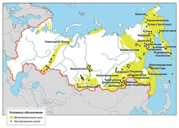
Map of Russian gold mines
The geography of gold mining in the Russian Federation looks extensive and diverse on the map. True, not all mined gold is suitable for industry. Deposits that are suitable for it are divided into endogenous and exogenous.
Endogenous deposits come in several types. The most appropriate production is in medium-temperature and high-temperature hydrothermal deposits. Also of particular importance are deposits formed as a result of volcanic activity.
Gold mines in Russia are found mainly where the deposits are located closest to the surface of the earth. For example, Khakanja in the Far East or Kuranahanskoe in Aldan. Gold is also mined from pyrite-polymetallic, magmatic copper-nickel deposits and from gold-bearing skarns.
conclusions
Of interest are the “lattice” statistics separately for the latitudinal and longitudinal distributions of 46 Russian gold mines (according to the “gold belts”).
Latitudinal distribution of gold mines in the Russian Federation
- from 70 to 65 N. — 4 (9% ~10)
- from 65 to 60 N. — 13 (28% ~30)
- from 60 to 55 N. — 11 (24% ~20)
- from 55 to 50 N. — 18 (39% ~40)
Longitudinal distribution of gold mines in the Russian Federation
- from 60 to 65 east. — 4 (9%)
- from 65 to 70 N. - 12%)
- from 85 to 90 east. — 2 (4%)
- from 90 to 95 east. — 3 (7%)
- from 100 to 105 east. - 12%)
- from 115 to 120 east. — 10 (22%)
- from 120 to 125 east. - 12%)
- from 125 to 130 east. - 12%)
- from 130 to 135 east. — 2 (4%)
- from 135 to 140 east. — 3 (7%)
- from 140 to 145 east. - 12%)
- from 145 to 150 east. — 3 (7%)
- from 150 to 155 east. — 4 (9%)
- from 155 to 160 east. — 4 (9%)
- from 160 to 165 east. — 3 (7%)
- from 165 to 170 east. — 2 (4%)
- from 170 to 175 east. - 12%)
Thus, the greatest concentration of mines falls on the range of geographical coordinates from 50 to 55 N latitude. and from 115 to 120 E. These mines are marked with an asterisk. They are included in the 4th gold-bearing zone, which coincides with the 4th gas-bearing zone (60 N 120 E - Yakutia). It may be necessary to change the coordinate of this GPS zone to 55 N latitude. 120 east
The parallel itself is 60° N. is a well-known latitudinal lineament stretching across the entire territory of Russia (the so-called “Okhotsk-Vychegda lineament”
) [also called
Okhotsk-Moscow
(No. 17 on the map of Eurasian lineaments)].
The meridian is 120° east. also a lineament (No. 10 - Sulawesi).