Introduction
Bolshevik Island is located in the Arctic Ocean at the northernmost tip of Russia (Severnaya Zemlya archipelago, 76–78° north latitude) in the economically undeveloped region of the Taimyr Autonomous Okrug. Belongs to the Taimyr-Severozemelskaya gold-bearing province (Fig. 1). Regional geological survey work here covers 80% of the territory; large-scale surveying with general prospecting (GGS-50) was carried out in individual areas without mining and drilling operations, and specialized prospecting and assessment of indigenous gold resources were not carried out at all until 1995.
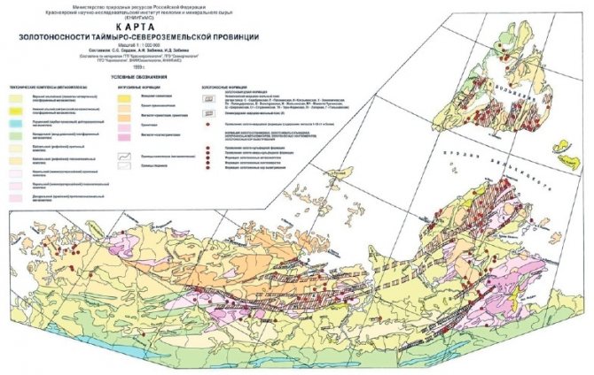
Rice. 1.
Taimyr-Severozemelskaya gold-bearing province [4]
Administratively the island.
Bolshevik (architect Severnaya Zemlya) is located on the territory of the Taimyr Dolgano-Nenets municipal district of the Krasnoyarsk Territory (Fig. 1). The nearest city of Norilsk is located 1125 kilometers away. Bolshevik Island is the land center of the Northern Sea Route between its western and eastern sectors. Due to a certain analogy in the geological structure and metallogeny, the history of geological development, with the Yenisei Ridge, the industrial potential of the island is beyond doubt.
To date, in the southern part of the island, placer gold has been identified within 11 large river valleys, and over 50 ore occurrences and points of mineralization of ore gold are also known (Fig. 1). Placers of gold on the island. Bolshevik was identified during the GGS-200, and ore gold was identified by V.G. Kuzmin at the First ore occurrence. In 1979–1983 on the island. Bolshevik carried out prospecting and prospecting work on the gold placer. Since the 90s, placers have been periodically mined (Table 1): first by the Polyus artel, then by the State Enterprise TsAGRE and Ruthenium LLC, RemServis-RB LLC, Kular-Zoloto JSC, etc., and in presently SESAR-Arctic LLC (annual production about 500 kg).
| Indicators | 1994 | 1995 | 1996 | 1997 | 1998 |
| Extraction of x, h, gold (kg) | 75,3 | 183,7 | 152,7 | 177,7 | 140 |
| Output per employee (kg) | 1,02 | 1,9 | 2 | 2,2 | 1,9 |
| Content per rock mass (mg/m3) | 360 | 530 | 520 | 430 | 402 |
Table 1.
Dynamics of gold mining on the island. Bolshevik for the period 1994–1998
The article was written based on the results of metallogenic and geological-economic analyses, as well as on the basis of the author’s expert assessments and available data published in the scientific and periodical press [1–5]. The main goal of the article is to show the prospects for the development of the gold mining industry on Bolshevik Island in the Arctic zone of the Russian Federation.
Area data
Bolshevik Island is located in an Arctic desert zone characterized by the development of continuous permafrost and modern cover-type glaciation.
The island is washed by two seas at once - the Kara and Laptev. It is separated from the mainland by the Vilkitsky Strait, and from the October Revolution Island by the Shokalsky Strait. Bolshevik Island has an area of 11,312 km2, which is almost a third of the entire archipelago. Its highest point is at 935 m. The topography of the island is predominantly flat with small hills, sometimes turning into hills. The coastline is very indented, there are many bays. The most significant bay is Akhmatova, which cuts into the land for almost 60 km. Thälmann Fjord and Mikoyan Bay also penetrate deeply. There are many bays along the coastline - Zhuravleva, Solnechnaya, etc. There are a large number of rivers here - Studenaya, Kamenka, Golysheva, Obryvistaya, etc., but there are few lakes here and all of them are small (Fig. 2).
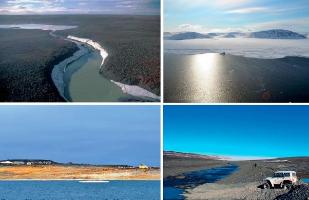
Rice. 2.
Types of Bolshevik Island (from left to right, top to bottom): r.
Cold; O. Bolshevik; Solnechnaya Bay; view of the glacier The climate on the island is Arctic marine.
The average annual temperature has remained at -14–16 °C for many years, reaching -40 °C in winter and rarely rising above +5 °C in summer. There is little precipitation - up to 400 mm per year, mainly from June to August. With a polar day lasting 140 days, the season with positive average daily air temperatures does not exceed 2.5 months. Even in summer, the soil thaws only at the surface. An area of over 3 thousand km2 is covered by glaciers (30% of the entire island), which never melt. The largest of them even received names - Leningradsky, Kropotkin, Mushketov. Considering the low temperature, frequent gusty winds and other unfavorable conditions, it becomes clear why Bolshevik Island is uninhabited. The weather here is very bad most of the year.
Despite the extremely harsh climate, many birds nest on the island; walrus and seal rookeries are known. Sometimes there are reindeer, wolves and arctic foxes, and polar bears. About 25 thousand years ago mammoths lived here.
Currently, the island is home to the Cape Baranova ice base of the Arctic and Antarctic Research Institute, as well as two closed polar stations (Solnechnaya in the south and Peschanaya in the north). Cargo is delivered by the Northern Sea Route from the port of Arkhangelsk, and workers and equipment are delivered by aviation from Krasnoyarsk through Khatanga and then by helicopter, and by sea. Movement around the territory is carried out by tracked and wheeled vehicles. Energy supply - diesel power plant. The area's exposure is quite good by geological standards.
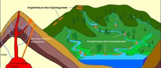
Mineral formation
Quartz has the property of crystallizing in different modifications. It all depends on the conditions under which the substrate for the reaction, that is, silica, is located. Most often, the substance crystallizes from acidic magma. Pegmatites grow together with feldspar and form a quartz core. If the process is hydrothermal in nature, the result is crystal veins.
At the same time, the stone is stable in surface deposits and placers of various origins. This fact explains that the stone is often found on river banks or beaches in crushed form or in the form of full-fledged crystals.
Geological structure of the island
Bolshevik Island is part of the ancient folded frame of the Siberian Platform, fragments of which in the southern part are the Yenisei Ridge and the Baikal-Patom Highlands [2, 5].
These regions are united by common geotectonic positions, Archean-Proterozoic age, metamorphism of various degrees - from greenschist facies to autochthonous and parautochthonous granitoids - and high gold content, both placer and bedrock. The latter is characterized by localization in weakly metamorphosed black shale strata and the absence of a clear connection with magmatism. Within the Taimyr-Severo-Zemlya folded area (Fig. 1), subaqueous black shale deposits are widespread, fine-grained, often thin-layered, predominantly dark-colored rocks of clayey, carbonate, siliceous or mixed composition, significantly enriched in organic matter (1–18%). Two large time levels of their accumulation are distinguished: Riphean and Lower-Middle Paleozoic (with a maximum in the Ordovician and Silurian). On about. The Bolshevik Lower-Middle Paleozoic black shale complex is absent [2, 5].
Sediments of the Riphean black shale complex are distributed on the island. Bolshevik and in the northern part of the Taimyr Peninsula, forming a strip 100–150 km wide along the coast from Minina Bay (in the west) to Thaddeus Bay (in the east) [2, 5]. The thickness of the complex is about 2 thousand m. In Western and Central Taimyr, the complex contains several horizons of black shales, the lower of which is recorded in the upper part of the Voskresensk strata, its thickness varies from 90 to 400 m. On the island. The Bolshevik thickness of the carbonaceous shale sequence is at least 700 m (the base of the sequence has not been exposed).
Types of gold ores
Gold is found 1) in all endogenous genetic types of ore deposits (with the exception of pegmatites), 2) in two types of exogenous ( weathering
and
placer
), as well as 3) in metamorphosed deposits. Hydrothermal, placer and metamorphosed deposits are mainly of industrial importance.
Gold ores are natural mineral formations containing gold in quantities at which it is economically feasible to extract it using modern production methods.
In addition to the actual gold ores
Gold-bearing ores
of copper, nickel, lead and zinc, silver, iron (ferruginous quartzites), and manganese, in which gold is an associated component, are known
There are (as mentioned above) endogenous
[underground],
exogenous
[surface] and
metamorphosed
gold ores.
Endogenous gold ores
All [probably, more accurately, most?] endogenous gold ores of hydrothermal
origin. They contain Au from 2-3 to several hundred g/t. They form massive plate-shaped veins (deposits of the Urals, eastern Transbaikalia, Kazakhstan in the CCCP, Porcupine and Kirkland Lake deposits in Canada, Ashanti in Ghana), saddle-shaped veins (deposits of eastern Siberia in the CCCP, Bendigo in Australia), deposits and pipe-shaped bodies of veinlet and stockwork ores (deposits of Uzbekistan in the CCCP, Homestake in the USA).
The composition of [endogenous?] gold ores is varied (up to 200 different minerals). Gold-sulfide-quartz ores predominate (ore minerals from 1.5 to 20%). The main vein mineral is quartz
.
Calcium and iron carbonates, barite, chlorite, sericite, and tourmaline are present in variable quantities. Among the ore minerals,
pyrite
most often predominates ,
and arsenopyrite
. They are subject to pyrrhotite, sulfides and occasionally occurring sulfosalts of copper and lead, zinc, bismuth, silver, iron oxides, native silver, bismuth, and in isolated cases - tellurides.
Hydrothermal gold deposits are quite common. All of them are multi-stage. Divided into plutonogenic
and
volcanogenic
. Plutonogenic associated with granitoid batholiths. They are characterized by ores of relatively simple quartz composition.
Hydrothermal high temperature deposits
Hydrothermal high-temperature deposits of the gold-arsenopyrite formation occur among granitoids and Precambrian metamorphic rocks. The ore bodies consist of quartz veins with visible gold and sulfides, as well as pyritized and silicified zones in the host rocks. Fine, difficult-to-recover gold inclusions are associated with arsenopyrite, pyrite and other sulfides (deposits of the Urals, Kolar in India, etc.). Deposits of this type are widespread.
Hydrothermal medium-temperature deposits
Hydrothermal medium-temperature deposits of quartz-sulfide and gold-quartz formations are represented by veins occurring within massifs of Paleozoic granitoids and in the host sedimentary rocks of the roof. The ores are composed of quartz, carbonates, barite and sulfides - pyrite, chalcopyrite, sphalerite, galena, fahlores, etc. Gold is present in native form in quartz and as an impurity in sulfides. This genetic type is widespread and has great industrial significance. In the CIS it includes some deposits of the Urals, Kazakhstan, Transbaikalia, etc., abroad - the Maternal Shila and Grass Valley deposits in the USA, Kalgoorlie in Australia, deposits in Ghana, Kenya, etc.
Hydrothermal low-temperature deposits
Hydrothermal low-temperature deposits of the gold-silver formation occur in effusive rocks and are spatially associated with areas of young volcanism. Ore bodies are represented by veins and stockwork zones formed at shallow depths. Mineralization is uneven, clustered (bonanza).
The ores contain chalcedony-like quartz, calcite, rhodochrosite, barite, adularia, sulfides, silver minerals, silver gold, and gold tellurides. Examples include the deposits of Transbaikalia and North-East Russia; abroad - Komstock, Goldfield, etc. in the USA, El Oro in Mexico, deposits in Chile, Peru, New Zealand, Indonesia, Japan, Romania, etc. In addition to gold, silver is extracted from ores.
Exogenous gold ores
Exogenous gold ores are contained in placers
, less often - in oxidation zones of gold-bearing sulfide deposits. In placers, gold ores are represented by loose and weakly cemented near-surface deposits that form ore layers and streams (eastern regions, the Urals and others in Russia, California, the Columbia and Yukon river basins, the Klondike River in Alaska in the USA, southern tributaries of the Amazon River, Brazil, etc. ).
Weathering deposits
Weathering deposits are represented by iron and lead caps of sulfide deposits, in which gold accumulates together with iron hydroxides, lead carbonates, and secondary silver minerals. Gold is released in the form of films in caverns and leaching cells. Sometimes, under conditions of free growth, crystals form.
Examples include iron caps of pyrite deposits in the Urals, Balkans, Japan, etc., oxidation zones of polymetallic deposits in Transbaikalia, etc.
Gold placers
Placer gold deposits continue to play a significant role as gold mining targets. The most common alluvial placers containing gold. Alluvial placers, in accordance with the conditions of occurrence, are divided into channel, valley
and
terraced
.
Channel and valley rivers were formed in Quaternary time. They are common in the basins of the Lena, Kolyma, Aldan, Amur, Yenisei and other rivers. Terrace placers formed earlier than valley ones and lie on longitudinal terraces. They are small in size, but the gold content in them is richer than in valley placers. Terrace placers are located in the Lensky district, Aldan, and Kolyma. Rich eluvial gold placers are known in Australia (Kalgoorlie district), where they are a product of lateritic weathering of gold-bearing quartz veins.
Marine placers are found along the seashores. They are formed due to the destruction of quartz veins and ancient coastal placers, poor in gold. The length of the Nome sea placer (Alaska) is 5 km, width 80-100 m. The gold content in the placer is in some places 200 g/t. Buried placers are widely developed. For example, the Jurassic placers of the Urals are buried under marine sediments of Cretaceous age or continental sediments of the Cenozoic; placers of Quaternary age in the North-East and Siberia are covered by glacial deposits.
Metamorphosed gold ores
Metamorphosed gold ores are associated with layers of gold-bearing conglomerates, less commonly gravelites
(Witwatersrand in South Africa, Tarkwa in Ghana, Jacobina in Brazil and Nallaghain in Australia, etc.). Gold in the form of grains, sometimes semi-rounded (size from 5 to 100 microns), is enclosed in quartz-sericite-chlorite cement, as well as in the form of thin veins cutting quartz pebbles. Manifested together with oxides and sulfides of iron and other metals. Au content 3-20 g/t, fineness above 900.
Metamorphosed deposits are represented by gold-bearing conglomerates - a product of transformation of ancient placers, mainly Precambrian. An example is the unique Witwatersrand gold conglomerate deposit in South Africa. However, geological conditions similar to those of the African shield are known on ancient shields of the East European and Siberian platforms, where Precambrian oligomictic and monoquartz conglomerates are recorded. The problem of identifying industrial deposits of gold-bearing conglomerates is of great practical interest.
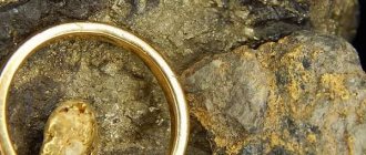
Gold content of Bolshevik Island
The black shale deposits of the region are of great mineragenic interest.
Deposits and occurrences of Au, U, V, Mo, Pt and other metals are associated with them. The manifestations of the gold-sulfide-black shale formation of the canyon of the river are associated with the Riphean black shale complex. Golyshev [2, 5]. There are also developed ore occurrences of a vein gold-quartz formation with very high metal contents – up to 200–400 g/t or more (up to 1–1.2 kg/t), some of which are represented by nuggets in chlorite-carbonate-quartz veins. On the rest of the island, among the terrigenous flyschoid sediments of the Riphean Vendian age, several ore occurrences with a gold content of up to 1075 g/t and many points of mineralization with a content of 1–5 g/t have been identified. The nature of the near-ore changes indicates the metamorphogenic-hydrothermal genesis of the mineralization in question, controlled by the intersections of submeridional shear zones with diagonal faults. Based on all of the above data, a metallogenic zoning of the archipelago was carried out, highlighting the epochs and stages of ore formation [2, 5]. In the southeastern part of Bolshevik Island, the most promising area of combining occurrences of gold-black-shale and gold-quartz ore formations has been identified (Fig. 3).
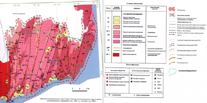
Rice. 3.
Lagerno-Golyshevsky gold mining district [5]
The most famous analogs of potential deposits of the Bolshevik region, according to researchers, are the Sovetskoe ore field (Yenisei gold-bearing region) and the Sukhoi Log deposit (Lensky gold-bearing region). Close in geological position are the saddle-shaped veins of the Bendigo-Ballarat ore district (Australia), the Muruntau and Aminzatau ore fields (Uzbekistan), and the gold-quartz deposits of Chukotka (Sovinoe) (Proskurnin and others) [2, 4, 5].
Types of gold deposits
Gold deposits occur mainly in areas of granitoid
, a small number of them are associated with basic and ultrabasic rocks.
Gold forms industrial concentrations in post-magmatic, mainly hydrothermal
, deposits.
Under exogenous conditions, visible gold is a very stable element and easily accumulates in placers
.
However, submicroscopic gold, which is part of sulfides
, upon oxidation of the latter, it acquires the ability to migrate in the oxidation zone.
As a result, gold sometimes accumulates in the zone of secondary sulfide enrichment, but its maximum concentrations are associated with accumulation in the oxidation zone, where it is associated with hydroxides of iron
and
manganese
.
Migration of gold in the oxidation zone of sulfide deposits occurs in the form of bromide
and
iodide
compounds in ionic form.
Some scientists allow the dissolution and transfer of gold with ferric oxide sulfate
or in the form of a suspension suspension.
They differ:
- primary gold deposits,
- placers into which it falls as a result of the destruction of ore deposits
- and deposits with complex ores in which gold is extracted as a by-product.
Indigenous gold and placers
Gold ores and placers are natural mineral formations, the content and total amount of gold in which are sufficient for the economically viable extraction of this metal. Gold is found in ores mainly in native form. It is not chemically pure, but is a solid solution with other metals, mainly silver. In addition, gold in ores is present in the form of tellurides (calaverite AuTe2, etc.), but they are not of great industrial importance. Gold deposits are divided into primary and alluvial.
Primary gold deposits
Primary deposits are represented by veins, vein systems, deposits and zones of veinlet-disseminated ores of various sizes and shapes. Ore bodies are confined to cracks, zones of crushing and shearing of rocks. Their thickness is from 0.05 to tens of m, their length is tens and thousands of m. The largest zones are: the Kolar vein zone in India (length 20 km, developed to a depth of 3.2 km, with an average thickness of the veins 1.2 m), the system lived Mather Lode in the USA (length 200 km); some vein zones of the Yenisei Ridge, mineralized zones of the Muruntau deposit in Central Asia. Gold deposits are known in fold belts, on platforms and in areas of tectonic activation.
Gold ore deposits were formed in different geological eras (from Precambrian to Cenozoic), at different depths (from tens of meters to 4-5 km from the earth's surface), usually in connection with large faults in the earth's crust, forming the so-called. gold belts. Their origin is associated mainly with the activity of hydrothermal waters. The mineral composition of gold ores is varied: quartz and iron sulfides (pyrite, marcasite) predominate, less often arsenic (arsenopyrite); there are sulfides and sulfosalts of copper, lead, zinc, bismuth, antimony, silver, oxides, carbonates. According to the composition and conditions of formation, the following formations are distinguished: 1) gold-sulfide-quartz, represented by quartz veins and streaks containing from 0.5 to 30% sulfides; gold is small and large (nuggets are also found), unevenly distributed, its content ranges from 10-50 to 1000 g/t (USSR, Canada, USA, Brazil, India, Commonwealth of Australia, Ghana, Southern Rhodesia); 2) essentially sulfide, represented by deposits, zones of veinlets and disseminated mineralization; finely dispersed gold, its content rarely exceeds 1-2 g/t, is extracted along with other metals - copper, zinc, lead, nickel (Tanzania, Namibia, Canada, Mexico, Australia).
Oxidation zones of ores (iron hats) of some copper-pyrite and polymetallic deposits are enriched with gold redeposited from primary ores and are independent objects for the extraction of the latter. Most of these deposits are located in the USSR (in the Urals and Kazakhstan).
Gold placers
Gold placers are gold-bearing loose (less commonly cemented) deposits of clastic material formed as a result of the destruction of bedrock deposits and gold-bearing rocks. According to the conditions of formation, the following main types of placers are distinguished: eluvial, deluvial, alluvial, coastal, marine and lacustrine. Alluvial placers, including modern riverbeds, valleys and terraces, as well as ancient buried ones, are of the greatest industrial value. The length of placers is from 1-3 to 25 km, rarely up to 50 and 100 km, with a width from 1 m to 200-300 m, sometimes up to 1 km or more; thickness 1-3m. Gold content is from tenths of g/m3 to tens of kg/m3. Gold placers were formed in different geological eras. Ancient placers are often buried under younger sediments and lie at a depth of 100-150 m from the surface of the earth. The richest gold placers are known abroad - in Canada (the basin of the Yukon and Klondike rivers), the USA (Alaska, California), Colombia, the Commonwealth of Australia, New Zealand, New Guinea, the Philippines; in the USSR (the basins of the Yenisei, Lena, Bodaibo, Vitim, Aldan, Kolyma, Yana and Indigirka rivers).
A special type of gold deposits is metamorphosed placers.
(gold-bearing conglomerates, less commonly gravelites). This type includes the world's largest gold deposit, the Witwatersrand in South Africa. (Source - https://studbooks.net/2401163/matematika_himiya_fizika/korennye_mestorozhdeniya_zolota)
Gold placers of Bolshevik Island
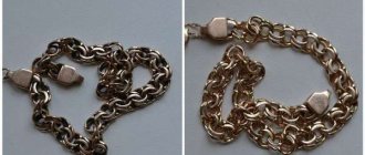
All streams and rivers within Bolshevik Island contain placers of gold (Fig. 4) [2–5]. The explored gold placers of the Golysheva River basin are localized in the middle-upper reaches of the main river and along its two main tributaries, where they collectively extend for almost 30 km [2–5]. The Basin includes placers of the river. Golysheva, b. Kovaleva and R. Loginova. Native gold in all placers of the basin is quite homogeneous and its typomorphic characteristics are very similar to each other. The form of gold is predominantly plates and tablets; flakes and rounded grains are also found (Fig. 5). The roundness is weak, and roughness is observed on the surface of the grains. Quartz ingrowths and inclusions of host rocks are found everywhere; sulfide ingrowths are much less common. Films of hydroxides are observed, which are usually developed in the recesses of gold grains, sometimes found in the form of a shirt. The average fineness of gold is 950 ‰. No spatial patterns of gold variability are observed throughout the placer [2–5].
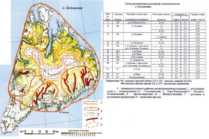
Rice. 4.
Bolshevik Island gold placers [5]
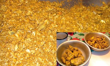
Rice. 5.
Placer gold river
Chilly on the island. Bolshevik Almost all noticeable placers of the southern part of the island. Bolshevik are in the distributed subsoil fund (8 licenses) and are involved in development. The total reserves of placer gold were: volume of sands - 8435 thousand m3; balance reserves of categories C1 and C2 - 11014 and 625 kg, respectively; off-balance sheet - 615 kg. Alluvial gold resources are 24.5 tons [5]. To date, a total of about 7.5 tons of gold have been mined, and exploration continues at some of the placers. Significant parameters of placers formed in relatively poorly developed valleys can apparently be determined by the richness of bedrock sources.
Primary gold deposits of Bolshevik Island
The ore gold resources of the Bolshevik region are assessed ambiguously. If their placer potential with a high degree of exploration is assessed quite fully (Fig. 4), then the ore potential still remains in the forecast estimates (Table 2) [2–5]. As can be seen from the table, in the southern part of the island. Bolshevik The gold-sulfide occurrences of the Golyshevskaya and Kovalevskaya zones (the Golysheva River basin) are of greatest interest for further study, within which significant predicted resources of ore gold have been identified [2]. The most promising Golyshevskaya area (1245 km2) is located in the southeast of the island. Bolshevik in the central part of the Kara arched uplift (Fig. 3).
| An object | Formation | Gold resources, t | ||
| Total | P2 | P3 | ||
| Grozny ore occurrence | Zolotoquartz | 4,3 | 4,3 | — |
| Nizhnelitkenskoe ore occurrence | 1,2 | 1,2 | — | |
| Primorskoye ore occurrence | 3,3 | 3,3 | — | |
| Vasilyevskoe ore occurrence | 0,6 | — | 0,6 | |
| Fokinskoye ore occurrence | 0,6 | 0,6 | — | |
| Serezhkinskoye ore occurrence | 0,5 | 0,5 | — | |
| Grozny zone | Gold sulfide | 9,3 | — | 9,3 |
| Golyshevskaya zone | 150 | 7,1 | 142,9 | |
| Kovalevskaya zone | 22,5 | — | 22,5 | |
| Ore occurrence First | Gold-sulfide-quartz | 5,2 | 5,2 | — |
| Lagerninskaya Square | 50 | — | 50 | |
| Tora-Kamenskaya Square | 37 | — | 37 | |
| Studeniska Square | 75 | — | 75 | |
| Total | — | 359,5 | 22,2 | 337,3 |
Table 2.
Forecast resources of ore gold in the southern part of the island. Bolshevik [4]
Golyshevskaya Square
The area is composed of rocks of the Golyshevskaya, Krasnorechenskaya and Slozhnenskaya strata, which are of Riphean age [5].
The oldest sequence - Golyshevsky - is represented by interlayering of wavy-layered dark gray to black meta-siltstones and meta-argillites with gray and dark gray with a weak greenish tint, different-grained meta-sandstones and meta-gravelites. The complete section of the strata has not been exposed anywhere; its established maximum thickness is about 500 m. The Krasnorechenskaya strata lies directly on the formations of the Golyshevskaya strata, as if crowning the section of the latter. Its composition is dominated by heterogranular meta-sandstones, interbedded with gray, less often greenish-gray meta-siltstones and meta-mudstones. The total thickness of the strata was calculated graphically and, according to various researchers, ranges from 150–250 to 300–500 m [5]. The Slozhninskaya sequence is represented by greenish-gray, green, less often cherry-gray meta-sandstones, meta-siltstones and meta-argillites, with a predominance of the former. It is divided into two sub-sequences with a total thickness of 600 m, and has an insignificant distribution within the Golyshevsky node. Throughout the Riphean section, carbonate (calcite and manganese-calcite) nodules are found in meta-sandstone layers, the sizes of which depend on the thickness of the host layer: up to 5–10 cm in diameter and up to 1–2 m in length [5].
The formation of sedimentary cover complexes of Cenozoic age was preceded by an era of regional peneplanation of the relief and the formation of linear weathering crusts, presumably of Late Triassic age, over Proterozoic rocks. Upper Quaternary sediments are represented by marine sediments of the Kazantsevsky and Karginsky horizons - sands, sandy loams, pebbles, gravels, boulders, less often silts, loams and clays. They lie on weathering crusts in the interfluve of the N. Litke - the Last and along the right side of the Last to its mouth. The thickness of the Upper Quaternary deposits reaches 30 m [5].
Igneous rocks are extremely rare in the Golyshevskaya area. The nearest large intrusive massif, the diorite-grano-diorite batholith of Solnechnaya Bay, is located 40 km to the east. On the western bank of the river. Golyshev is aware of a dyke of massive perphyritic dolerites of the Near Ostrovsky complex. Single spessartite dikes of the Severozemelsky complex were discovered in the area of the Nizhnelitken and Serezhkinsky ore occurrences. Along the strike, the dikes are subconformable with the host geological structures. The thickness is insignificant - a few meters, the length is up to 1–1.5 km [5].
The flyschoid strata of the Golyshevsky gold ore cluster are intensively compressed into linear folds and broken by a significant number of faults. The strike of the folded system is north-northeast, 10–15°. A first-order plicative structure is the Golyshevskaya anticline, the eastern wing of which is hidden by the waters of the Laptev Sea, the western one is cut off by the Golyshevskaya fault system. The anticline is complicated by numerous conformally oriented folds of higher orders. The predominant dip of the axial surfaces of the folds is east-southeast.
Most of the faults strike north-northeast and northwest. Faults of north-northeast strike, mainly reverse faults and reverse-slip faults, coincide with the strike of folded structures and were formed synchronously with the latter, during the period of folding. The fault planes dip to the east-southeast. Northwestern faults are most often strike-slip in nature. Their formation is apparently associated with the period of Late Paleozoic-Early Mesozoic tectonic-magmatic activation.
The main prospects of the Golyshevskaya area are associated with gold-sulfide (gold-pyrite) zones confined to submeridional fold-fault structures. Their significant size and analysis of the most studied object (Golyshevskoye ore occurrence, average gold content - 3.05 g/t) show the possibility of discovering medium and large deposits with sufficiently high gold contents, suitable for open-pit mining [2–5]. At the same time, the probability of confirming previously established and discovering new ore bodies within the identified zones is extremely high and is due to the presence of placer deposits, zones and ore occurrences of the gold-quartz formation, as well as the fact that numerous gold-sulfide formations were not only observed, but also tested directly as in natural outcrops, and in ditches and wells, but due to lack of funds they did not receive proper analytical coverage, since the search project was stopped due to the cessation of funding with the preparation of a report on the fact of execution at the time of closure of the object.
Sulfide mineralization is mainly represented by pyrite, marcasite and pyrrhotite. On the flanks of the zones, pyrrhotite and the pyrite and marcasite that replace it form thin lens-shaped cuts 1–2 mm long and less than 0.5 mm thick. However, sulfide saturation can reach 1% of the rock volume. Further (often while the grooves are preserved) disseminated cubic crystals of pyrite appear, ranging in size from 1–3 to 10–15 mm, rarely up to 4 cm. A specific feature of sulfidization zones is the presence in them of organic formations replaced by semi-amorphous silica or pyrite. Gold contents in samples taken across the Golyshevsky ore occurrence range from background to 59 g/t. The maximum metal contents were obtained by sampling lens-shaped sulfide layers of increased thickness, the gold content of which reached 200 g/t [2–5].
Within the Golyshevsky ore field, in two of the seven zones of ore mineralization, bodies of single closely spaced carbonate-quartz veins and quartz-vein zones with a productivity of more than 20 g/t have been identified. Thus, in the Nizhnelitka zone of ore mineralization, a bundle of steeply dipping veins with a content of up to 257 g/t (average - 27 g/t with a thickness of individual veins of 0.4 m) was continuously traced for 120 m [2–5].
The main features of the ore bodies of the Golyshevsky gold ore field are as follows [2–5]: 1.
Localization in carbonaceous-terrigenous, weakly metamorphosed strata.
2.
No obvious connection with intrusive activity.
3.
Confinement to the locking parts of linear anticlinal structures.
4
.
Control with folded reverse faults. 5.
Levels in the distribution of mineralization (from bottom to top: sulfidization, vein zones, and veins in detachment fractures).
6.
Significantly pyrite composition of sulfide zones.
7.
Extremely uneven distribution of gold and a small amount of sulfides in the vein bodies.
In the process of carrying out geological survey work on a scale of 1:50000 at the Golyshevskoye ore occurrence, a relatively small amount of mining and drilling work was carried out, accompanied by furrow and core sampling. As a result, two extended concordant zones with a thickness of 4.4 and 8.6 m with an average gold content of 1.87 and 6.48 g/t, respectively, were identified in the black shales through drilling and clearing. In the surrounding (weakly pyritized) rocks, the gold content does not exceed hundredths, rarely tenths of a gram per ton. According to TsAGRE employees, the predicted resources of the zones are estimated at category P3 at 107.5 tons [2].
Currently, the Golyshevskaya area is fully prepared for carrying out prospecting and evaluation work for ore gold with a high probability of identifying a large industrial deposit [4].
Gold-quartz deposits
Gold-quartz deposits in the southern part of Bolshevik Island are represented by the Nizhnelitkenskoye, Fokinskoye, Primorskoye, Serezhkinskoye, Vasilyevskoye, Groznenskoye, Pauk, Sobachye ore occurrences (Fig. 3).
Gold-quartz veins, as a rule, are localized in zones influenced by reverse faults and strike-slip faults of submeridional strike. According to the structural position, two main types of vein bodies are distinguished: 1) linear vein zones in the cores of folds; 2) a series of thin veins in detachment cracks on the wings of folds. Both types can occur both together and separately from each other [2–5]. Vein zones of the first type are an alternation of relatively thick (up to 4–6 m) swells with thin vein intervals. Along the strike, the vein zones were traced at intervals of hundreds of meters - the first km (control is carried out by undulation of fold hinges). The contacts are uneven and characterized by structures of metasomatic replacement: banding, an abundance of xenoliths of the host rocks, often intensely chloritized and sericitized.
Veins of the second type are located en echelon in relation to the planes of reverse faults, as a rule, in uplifted blocks. They have a small thickness - 10–30 cm, rarely - up to 50 cm, a length of tens, a few hundred meters and form close zones that unite up to several dozen veins. The veins are characterized by crusty and banded textures of the so-called “book quartz”, indicating both formation in open fractures and during the replacement of host rocks. The veins dip due west at an angle of 40–60°. The total length of the zones reaches a few kilometers with a width of tens of meters [2–5].
The main nonmetallic mineral of the veins is quartz. Carbonate (on average 3–5% of the vein composition) is represented by calcite. In addition, chlorite is found that forms thin (from 0.002 to 0.02) aggregate idioblasts on quartz, characteristically of a “worm-like” shape, with the orientation of individual flakes perpendicular to the elongation of the intergrowth, or in association with fine-flaked sericite, it creates cracks in quartz and the vein core. The content of the heavy fraction in carbonate-quartz veins usually does not exceed grams/tens of g/t. It is represented mainly by minerals of iron, lead, copper and zinc: pyrite, galena, and less commonly chalcopyrite and sphalerite. Significant contents of cerussite, jamesonite, boulangerite, chalcocite, bornite, covellite, malachite, fahlores, pyromorphite, native copper and lead are noted. Arsenopyrite is also quite common, sometimes forming local outbreaks that sharply increase the content of the heavy fraction in the veins to 10% (the northern flank of the Serezhkinsk and the central part of the Nizhnelitken ore zones). Rarer ore minerals are molybdenite, scheelite, and cinnabar. The texture of the ores is disseminated, veined-disseminated, and sometimes veined. Gold is present in two generations: the first - in the form of small (less than 0.01 mm) syngenetic dissemination in sulfides, mainly in arsenopyrite, less often in galena and pyrite. It is observed in the form of rounded, rounded-isometric, microinterstitial and microveined deposits, sometimes in intergrowths with other inclusion minerals - galena, pyrrhotite and chalcopyrite. Later, gold II cuts sulfides along cracks, grows on them, and also cements quartz and carbonate, and is present in quartz burrows along the backbone of veins in contact with the host rocks. Its size is very diverse: from micron-sized sediments to 0.3 mm in sulfides and from 0.05 to 1-2 cm in quartz and carbonate. The distribution of gold in the veins is very uneven. Along with ore columns containing tens and hundreds of grams per ton, practically sterile intervals are noted. The composition of gold (microprobe determinations) corresponds to high-fineness: for gold I - 950–965 (average 958.17), and for gold II - 957–979 (average 966.6). The composition of impurities is identical with a slight increase in the average mercury content in late gold (0.6 versus 0.03%), as well as a relatively higher copper content (0.033 versus 0.01%) in Au I [5]. It should be noted that the technology of ore enrichment has not been studied. By analogy with other gold-quartz objects, ores are easily processed using a low-cost, non-energy-intensive gravitational method without fine grinding (mills).
The results of the searches carried out with extremely insufficient funding (25% of the project defined) give grounds to assert that the first industrial reserves can be assessed in the next 2–3 years, and the technological properties of the ores make it possible to plan associated mining at the exploration stage at a level of a few tens of kilograms per year [4].
Primorskoye ore occurrence
In the central part of the Primorsky zone of ore mineralization, drilling UKB wells and exploratory ditches traced from the surface a productive ore zone with a length of more than 800 m and an outcrop width of 3–10 m with a gold content according to UKB and ditches of up to 23 g/t (Fig. 6) [3 ]. The zone has been traced to a depth of up to 70 m. Here, in addition to intense quartz veining, carbonate-quartz ore bodies with a thickness of up to 5.5 m (with a total thickness of silicification zones of over 9 m) with a productivity of more than 40 g/t have been undercut. The results of the searches carried out with extremely insufficient funding (25% of the project defined) give grounds to assert that the first industrial reserves can be assessed in the next 2–3 years, and the technological properties of the ores make it possible to plan associated mining at the exploration stage at a level of a few tens of kilograms per year . Ores are easily processed using a low-cost, non-energy-intensive gravitational method. In the field area, ditches and trenches have been made, access roads and drilling sites have been prepared (Fig. 6).
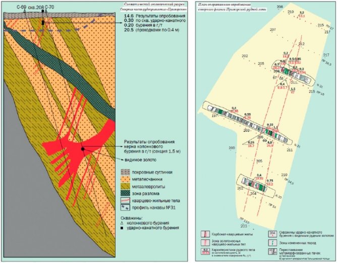
Rice. 6.
Geological section and plan of the Primorsky ore zone [3]
Deposits Groznenskoye, Nizhnelitkinskoye, Zhilnoye
Using a probabilistic approach, a preliminary economic assessment of the effectiveness of the development of gold-quartz objects in the southern part of Bolshevik Island was carried out, based on the amount of reserves, content, market conditions, and the current state of the gold raw material base in the region [1]. As can be seen from the diagram in Figure 7, built for gold deposits with open-pit mining, the Groznenskoye, Nizhnelitkinskoye, Zhilnoye primary gold deposits are significantly superior to the others in their main characteristics.
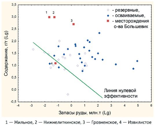
Rice. 7.
Diagram "reserves-content" of gold deposits in the Krasnoyarsk Territory, including the island.
Bolshevik [1] To assess the probability of development of these deposits, the predicted resources were transferred to the conditional category C1 using coefficients developed by Rosnedra.
The calculated probability of involvement of these fields was 0.9, which significantly exceeds the values for other reserve fields in the Krasnoyarsk Territory [1]. An assessment of the costs of developing the studied deposits, carried out using the development probability indicator, showed that the specific operating costs per gram of gold are $5.6 (Groznenskoye), $7.8 Nizhnelitkinskoye), $9.3 (Zhilnoye). This will allow achieving efficiency of development (as the ratio of price to cost) 8; 5.8 and 4.8, which is higher than the average for gold production in the region [1]. Thus, in terms of gold reserves, the Groznenskoye, Nizhnelitkinskoye and Zhilnoye deposits are not considered large. However, their main characteristics (reserves and ore quality) are not inferior to most of the world’s vein deposits, and we can talk about a high probability of their involvement in development. The reserves of the Izvilistoe deposit are significantly lower in content and, compared to the world ones, are marginally effective [1].
Prospects for the development of gold mining
The first step in the development of gold ore deposits on the island.
Bolshevik may include prospecting and appraisal work at the expense of the federal budget within the highly promising Golyshevskaya gold-sulfide area and involvement in the licensing process (in a mode that is gentle for subsoil users) of gold-quartz formation manifestations with high gold contents identified for artisanal mining [4]. For priority exploration, it is very important to select the most promising site, among ore occurrences widespread in the southern part of Bolshevik Island (Fig. 3). To do this, it is necessary to carry out reconnaissance field expeditionary work, the results of which will clarify the boundaries of the licensed area.
The weak link in the development of SMEs on the island is the insufficient energy supply, which does not allow the implementation of large-scale projects here. Due to the production of liquefied natural gas (LNG) on the Yamal Peninsula, energy supply to Arctic villages and bases along the Northern Sea Route at reasonable prices using LNG is becoming a reality.
1.
Bragin V.I., Matsko N.A., Kharitonova M.Yu.
Assessing the efficiency of developing promising copper and gold deposits in the Krasnoyarsk North // Arctic and North. 2021. No. 26. pp. 5–13. 2.
Prospecting and prospecting and evaluation work for ore gold in the southern part of Bolshevik Island.
Inform. report of the Severozemelskaya GRP DTSAGRE on the actual state of work for 1997–2002; executive A.V. Cherepanov. - Norilsk, 2002. 3.
Rochev N.V., Vanyunin N.V., Listkov A.G., Benz M.I., Lazarev F.D.
Prospects for the development of resources of the Bolshevik ore-placer region of the Taimyr-Severozemelsky gold-bearing province // Mining Industry. 1999. No. 2. P. 20–22. 4.
Samoilov A.G., Proskurnin V.F., Romanov A.P.
Raw material base of ore gold on Bolshevik Island // Mineral Resources of Russia. Economics and Management. 2021. No. 1–2. pp. 42–47. 5.
Solid minerals of archipelagos and islands of the Arctic continental margin of Eurasia (Proceedings of NIIGA-VNII Oceangeology. T. 216) / Ch.
editor V.D. Kaminsky. St. Petersburg: VNII Okeangeologiya, 2010. 336 p. Published in the magazine “Gold and Technology” No. 2/June 2020
Patterns of high gold content in quartz veins at the Akbakai deposit
Key words: sample, vein, gold content, deposit, gold distribution, ore columns, fault, junctions
The relevance of this topic lies in the fact that patterns can serve as a basis for continuing prospecting and assessment work; taking them into account will increase the efficiency of geological exploration and lead to acceleration and saving of work, and will also make it possible to make new theoretical forecasts. The end result could be an expansion of the indigenous gold resource base.
The Akbakai gold deposit was discovered in 1969 by the Zhetysu gold mining expedition during a detailed search for gold (Duisenbekov D.D. et al.).
The Akbakai field area is part of the largest geological structure in Kazakhstan - the Chu-Balkhash anticlinorium. It includes the Zhalair-Naiman and Sarytum geosynclines, separated by the narrow Zheltau geoanticline. The main structure that determined the geological development and its metallogeny is the Jalair-Naiman zone of deep faults. The Akbakai deposit is localized at the junction of the Sarytum and Jalair-Naiman geosynclines. The main elements of the geological structure of the Akbakai field are:
1) host rocks of diorite-granodiorite composition, which are competent rocks for both sustained fracturing and hydrothermal-metasomatic ore formation;
2) manifestation in several stages of fractured discontinuous structures of systems 2 and 4;
3) intrusion of dike formations of different ages along cracks;
4) manifestation of a multi-stage hydrothermal process with gold deposition along fracture structures (zones).
The quartz veins of the Akbakai deposit carry out sub-latitudinal fractures and are controlled by dikes of lamprophyre composition. In total, 16 veins with balance ores of industrial categories have been explored at the deposit (Fig. 1).
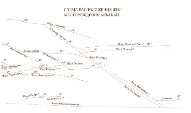
Rice. 1. Layout of veins at the Akbakai deposit
According to the mineralogical composition of the ores, the Akbakai deposit belongs to the gold-sulfide-quartz formation. The main useful component is gold. According to its morphological features, occurrence conditions and internal structure, the deposit belongs to a low-thickness quartz vein, mineralized zones with disseminated mineralization and fine-veined silicification.
In general, the Akbakai deposit is characterized by sharp variability in the thickness and internal structure of mineral bodies, a very uneven distribution of the main valuable components and belongs to the 2nd group of complexity in accordance with the classification of reserves.
Migrating through the strata, the solution captured finely dispersed gold, transferring it into the composition of colloids, and became enriched with it as it moved further. Having reached the cavities of interlayer exfoliation, colloidal gold, through contraction, formed finely dispersed aggregates, which over time increased to the size of nuggets [3]. Under conditions of folding, the scale of the manifested kinetic and, therefore, thermal energy is large enough for the temperature of the solutions in the displaced zones to rise above the melting point of gold. Therefore, it can be assumed that nuggets are formed in a homogenized vapor-liquid medium by merging microdroplets of a former colloidal solution into nuggets under the action of surface tension forces. Currently [4] it is believed that the formation of nuggets occurs exclusively in gold-supersaturated quartz solutions with temperatures in the first hundreds of degrees. Further, residual water in granodiorites dissolved the quartz grains contained in them. The silicate solution thus obtained simultaneously filled the interlayer cavities with colloidal gold, thereby forming ore-bearing quartz veins.
During the formation of folding in rocks, favorable physical and chemical conditions are created for the formation of gold-quartz veins based on the hydrothermal process. Nuggets can also form under conditions of high temperatures, which ensure the melting of gold particles.
Considering in general terms the distribution of gold in the plane of ore bodies, it can be noted that their central parts are enriched. Against the background of this general pattern, local areas of rich ores stand out. Their sizes range from a few meters in diameter to 40–50 m, rarely more. The experience of operating the deposit has shown full compliance of the geological boundaries of the ore bodies with the actual observed ore distribution. Almost all increased concentrations of gold are concentrated within geological boundaries. Outside of them, weakly hydrothermally altered rocks contain, as a rule, up to 1.0 g/t gold (Fig. 2).
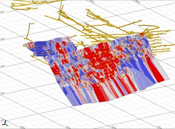
Rice. 2 Block model of the ore body of the Akbakai deposit
Against the background of a general inclination of mineralization to the west, ore columns (6 columns) were identified, the position of which was determined by a number of structural elements. The location of ore columns (sites), a number of defining structural elements and their parameters are given below:
− the area where the Glavnaya and Oktyabrskaya veins meet with a length of 25 m (20 m horizon between profiles XVI-XVII);
− area of connection between the vein and the lamprophyre dike, 65 m long (20 m horizon near profile XVII);
− area of intersection of the quartz vein dike of lamprphyres for 25 m (20 m horizon near profile XXII);
− the area where the vein intersects and is displaced by 5–6 m by two transverse discontinuities over a distance of 20 m (100 m horizon, west of profile XVIII);
− the area where the vein splits into two branches, the intersection of one of the branches of the lamprophyre dike, the intersection and displacement of the ore body by a fault over a section of 40.0 m (100 m horizon near profile XVIII-XX);
− the area of conjugation and intersection of the ore zone (vein, dike) with the granodiorite-porphyry dike and the presence of small transverse discontinuities with complications of the morphological structure of the vein in the places of conjugation and intersection.
In the described section of the vein, two ore columns were identified, associated with the intersection of a lamprophyre vein dike.
The first, not clearly defined column is located on the western side of the intersection, its length is about 60 m. Obviously, an ore column of a higher order is superimposed on it, controlled by a transverse discontinuity, the content in the vein itself reaches 167.5 g/t.
The second, very rich ore column is associated with the divergence of the ore vein and the dyke, and possibly with its splitting. Its length is 40 meters, the gold content is three and four digits. In the area of joint development of the vein and dike, the gold content corresponds to the average level for the vein. In addition to these ore columns, an increased gold content (6–8 g/t against the background of off-balance ores) was established at the intersection with the Frolovskaya vein (profile XXVII), which is non-industrial here.
Increased concentrations of gold begin at the junction with the Glavnaya vein (120 m drift). This segment of the ore body, which has a strike of 15–20°, is attributed by us to the Pologaya 1 vein. It is possible, however, that it is a continuation of the Tukenovskaya vein already in the hanging block of the Glavnaya vein.
The ores of the Akbakai deposit are divided into primary sulfide and weakly oxidized according to the degree of oxidation. Currently, the second type of ore is completely mined. In fact, the reserves remaining in the bowels are represented only by primary ores. The mineralogical composition of primary ores is quite simple. The main ore minerals are arsenopyrite, pyrite, gold, sphalerite, chalcopyrite, stibnite, galena, fahlore, of which the first two minerals account for more than 75% of their volume. The sulfide content in the upper horizons of the deposit is 7–10%, decreasing with depth along steeply dipping veins to 4–5% and in gently dipping veins to 1.5–2.5%.
As a study, laboratory tests were carried out on 13 samples, consisting of sieving the original ore into two fractions (+150 mesh, -150 mesh or +0.104 mm, -0.104 mm) and fire assay analysis of each ore fraction (Table 1). This technique is called screen analysis. The technique is used for samples with uneven distribution of gold. Samples were taken from exploration wells, 7 (seven) of which were taken from the central part, i.e., the area of rich ores, and 6 (six) from outside the central part, where samples with moderate gold content. Data from the first seven samples indicate different classes of gold fineness and its uneven distribution. Based on the next six samples, we can say that the samples contain fine gold, that is, small “invisible” gold in sulfides.
Table 1
Screen analysis data

Conclusion
It was noted above that a characteristic feature of the ore bodies of the Akbakai deposit is the presence within them of local areas characterized by high gold content. Such areas are called concentration ore pillars. When conducting detailed exploration, certain structural criteria are established that control them.
The most common pattern at the Akbakai deposit is the fact that the central parts of the veins are enriched in gold. Along the fall, rise and flanks, gold content gradually decreases.
The deposit has geological and structural elements of various types that control ore columns of different areal sizes. Large structural elements (West Akbakai Fault), contact of the Kyzylzhartas intrusion, some submeridional faults, areas of conjugation of steeply dipping veins on the western flank predetermine the western declination of both ore bodies and large columns within the steeply dipping Glavnaya, Frolovskaya and Zolotaya veins. The steep (50–60°) plunge of the ore columns to the west coincides with the dip of the above structural elements. The dihedral angle formed by the Western Akbakaysky and Beskempirsky faults has a southwestern plunge and may have been the direction along which melts and ore solutions circulated. The interface lines between the quartz veins and the Main vein are the second most important structural element, controlling the general direction of the ore columns. This control factor is clearly visible in the examples of the Oktyabrskaya and Tukenovskaya veins. In the flat Yubileinaya and Gentle 1 veins, the contours of rich ores are generally parallel to the lines of their junction with the Main vein.
Against the background of the general pattern of placement of rich ores and large columns, high-order ore columns stand out, which are often recorded by two to three intersections (length in plan up to 10 m), and sometimes more extended - from 20–40 to 60 m. They are controlled by the geological and structural elements listed below (in order of decreasing importance) or their combinations.
- Interfaces of quartz veins. Near the junctions and directly in them, one of the veins is enriched in gold, while the second vein is characterized by medium or even low gold content. Often, areas of industrial veins turn out to be rich when secondary, usually flat, veins approach them. The richest and most extensive is the ore column of the Yubileinaya-60 vein, which tends to be conjugate with the Pologaya 1 vein. The gold content of the latter vein in the conjugation area is low.
- Intersection of ore-controlling lamprophyre dikes by quartz veins. Ore columns are confined both directly to the intersections themselves and to the areas where the vein approaches the dike. In the latter case, they are somewhat longer.
- Transverse pre-ore faults are a widespread structural element. The associated ore columns have, with few exceptions, small areal sizes, but very high concentrations of gold.
- Areas where the morphology of ore bodies is complicated by bending of veins in plan or section and their splitting.
- Internal dikes. In total, two ore columns associated with intra-ore dikes were noted, but there could be significantly more of them.
Literature:
- Danilov V.I., Dursunov A.D. Report on geological exploration work at the Akbakai gold deposit for 1971–74. // Nikolaevka, 1974
- Yarensky Yu. E., Los V. L. Recalculation of reserves of the Akbakai deposit. Part I // Almaty, 2000
- Burakov A. M., Ermakov S. A., Blinov A. A. Forms of gold content and prospects for metal extraction from the sands of the Kuranakh buried placer. // Placers, sources, their genesis and prospects. — Materials of the conference dedicated to the 90th anniversary of the birth of I. S. Rozhkov and Yu. N. Trushkov. - Yakutsk: YSC SB RAS, 2000. - P. 196–201.
- Samusikov V.P. Gold nuggets - conditions for their formation (using the example of deposits of the Yana-Kolyma belt). // Notes of the Russian Mineralogical Society. - 2011, No. 4. - P. 38–55.